Homestake Mining Company -- McLaughlin Mine
Geology of the McLaughlin Deposit (page 2)
By Dean Enderlin, 2002

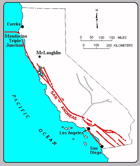
Approximately 3 million years ago, the leading edge of the San Andreas Fault system (the Mendocino Triple Junction) migrated northward past what is now the San Francisco Bay Area. In its wake, subduction ceased and was replaced by transform (right lateral strike-slip) plate motion. Regional uplift and transtensional fault activity in the Coast Ranges produced numerous structural basins (including Morgan Valley) in the region. The map below shows the present location of the Mendocino Triple Junction and San Andreas Fault relative to the McLaughlin mine. Adapted from CDMG map.
| Extensional tectonics, combined with thinning of the lithosphere in the wake of the Mendocino Triple Junction, produced regional volcanic activity. The McLaughlin deposit lies in the northernmost and youngest of the volcanic fields produced by this process. This field is called the Clear Lake Volcanics, and its age ranges from about 2.2 million years ("Ma") to about 10,000 years. The field is still potentially active, with magma bodies lying beneath Clear Lake and The Geysers. The image at right is a geologic map extracted from the CDMG Santa Rosa 1:250,000 quadrangle. The Clear Lake volcanics are shown in an orange-colored belt extending from the lower right to the upper left of the map. | 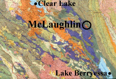
|
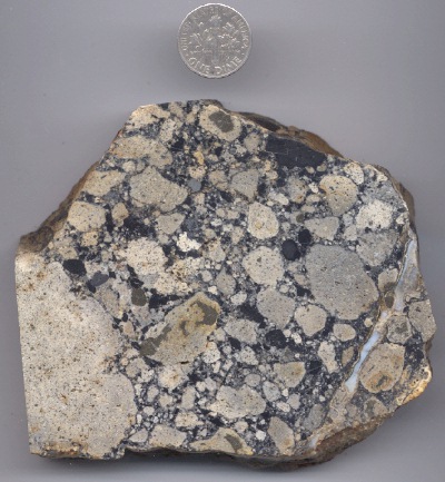
| Clear Lake Volcanics in the vicinity of the McLaughlin mine are the oldest in the field (K-Ar age = 2.2 +/- 0.2 Ma). They are basaltic andesite intrusives that ascended along kinks and bends in the Stony Creek fault plane when the fault was still active. The initial eruptions were phreato-magmatic and explosive in nature, driven by highly fluidized mixtures of magma and wallrock (diatremes). The first eruptions emplaced broad blankets and conical craters (maars) of volcanic debris (agglomerate) across what was then a lake- or marsh-filled valley. The image at left shows a typical agglomerate, with subrounded clasts of argillized basaltic andesite and various other wallrock lithic fragments (including adularized mudstone). D. Enderlin image. |
| As surface water boiled away or was displaced by surface volcanic deposits, the eruptions changed to lava flows which spread across the gentle topography of the basin to form a continuous protective cover. Today, these flows appear as harsh, rocky slopes with scattered blue oaks and thin grassland cover. The image at right was taken on the ridge just northwest of the mine pit. McLaughlin mine photo. | 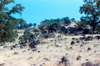
|

| At left is a basaltic andesite lava flow exposed at the McLaughlin mine North Pit. This particular flow shows columnar joint patterns similar to those seen at Devil's Tower, WY and Devil's Post Pile, CA. The joints are polygonal fractures produced in certain types of lava during cooling. D. Enderlin photo. |
| In the last two million years, the topography has inverted, and the ancient lava-filled valley is now a high point in the watershed, protected by the resistant lava carapace. The image at right shows the approximate limit of the lava flows (shown in yellow) on a 1981 aerial photo. The "San Quentin" workings of the old Manhattan mine appear as a white area near the center of the view. Total length of the volcanic cover is about 2 miles. D. Enderlin graphics. | 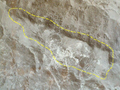
|
| Like The Geysers geothermal system west of Clear Lake (left), the McLaughlin gold deposit was formed from geothermal heat. Shallow ore deposits of this type are classified as epithermal deposits. The heat that formed the McLaughlin deposit came from the local magmatic activity. It is thought that the driving heat source for the McLaughlin deposit was a second pulse of magma, which ascended about 1 million years after the local basaltic andesite eruptions. This second episode may have involved a larger, perhaps silicic, magma body of a scale large enough to sustain hot springs activity for several hundred thousand years. Photo courtesy The Bancroft Library. |
| Prior to the onset of gold mineralization, the initial geothermal activity in the district produced chemical alteration of certain rock types that were adjacent to the thermal pathways in the faults. One of the most common types of alteration is a rock called "silica-carbonate," that is the byproduct of the interaction of carbonated thermal waters with serpentine. The image at right is silica-carbonate, where the serpentine is entirely replaced by common opal. The carbonate portion (usually magnesite) is not always present. D. Enderlin photo. | 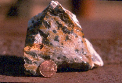
|
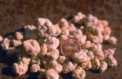
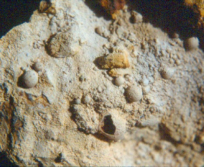
| Magnesite (magnesium carbonate) is found throughout the region. It often appears as irregular nodules replacing serpentine, as shown in the image at left. High quality magnesite crystals were also found in the McLaughlin mine pit. D. Enderlin photo. |
| The opal content of silica-carbonate rock tends to make it more resistant to erosion than the softer surrounding formations. As a result, silica-carbonate zones often stand out in bold relief to the surrounding landscape. The silica-carbonate spire at right is called the "pinnacles" or "eagle rocks." It is located north of the McLaughlin mine pit, and is directly in the plane of the Stony Creek fault. In the early days, miners used to call this rock "quicksilver rock," because its brittle nature made it a favorable host rock for vapor-phase mercury enrichment. McLaughlin mine photo. | 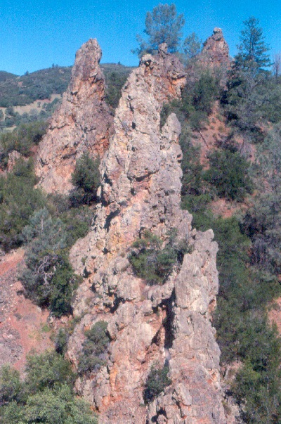
|
| An odd, but widespread, texture found in silica-carbonate alteration is the "froth vein," named for the bubbly appearance it presents. When intact, the silica bubbles usually contain globules of bitumen, tar or flowing oil. They are an example of a type of fluid inclusion. In the Redington mine, a cavity reportedly yielded several barrels of flowing green oil many years ago. The miners collected some of it, and mostly out of curiosity, used it to lubricate their mining equipment! The specimen at left comes from the Reed mine. D. Enderlin photo. |
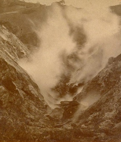
| An intact subaerial sinter (siliceous hot spring deposit) capping a portion of the multistage gold vein system was an especially important feature of the McLaughlin deposit, in that it demonstrated that the deposit was a completely preserved hot springs-type epithermal system. K-Ar ages from vein adularia and hypogene alunite bracket the age of the system between 1 Ma and 0.5 Ma. The sinter terraces formed a hill which was known as the San Quentin. When the hot springs were active, the terraces would have formed in the same manner as those of Yellowstone (see historic view of Mammoth hot springs at right). Click here to see examples of the San Quentin sinter from McLaughlin. Photo courtesy The Bancroft Library. | 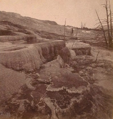
|
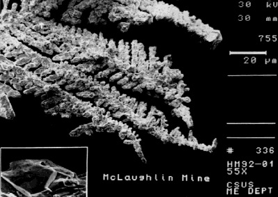
| Gold (primarily as electrum) precipitated as dendritic growths associated with silver sulfosalts in a zone of boiling extending over 350 m beneath the level of the sinter cap. Dissolved gold precipitated in this zone because, at shallow levels, where the confining pressure of the rock was reduced, hydrogen sulfide gas effervesced out of the water. Deeper in the system, where hydrogen sulfide stayed dissolved, it formed an ionic complex with gold and silver. These "bisulfide" complexes are what transport dissolved precious metals upward to the shallow hot springs zone of deposition. The ore-forming fluid was of meteoric origin, with recharge of the convective geothermal cell being enhanced by favorable Middle Pleistocene paleoclimatic and geomorphologic factors. At left is a scanning electron photomicrograph image of McLaughlin mine gold dendrites. Image courtesy California State University Sacramento geology dept. |
| Next Page Previous Page | McLaughlin Deposit Page 1 2 3 4 5 |