Homestake Mining Company -- McLaughlin Mine
Geology of the McLaughlin Deposit
By Dean Enderlin, 2002

The McLaughlin mine lies 115 km north of San Francisco in the Coast Ranges geomorphic province of Northern California. The deposit formed at the fault boundary between Mesozoic lithotectonic units called the Coast Range Ophiolite and the Great Valley Sequence.
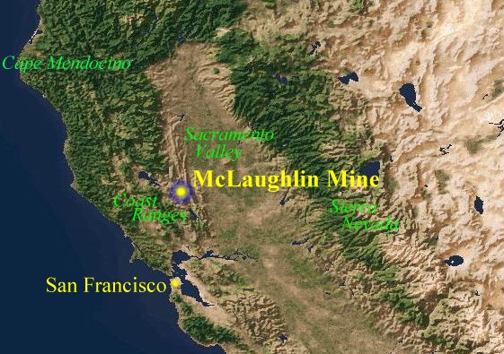
| To the west of the fault is the Jurassic Coast Range Ophiolite, made up of intensely tectonized seafloor ultramafic rock (serpentine), mafic volcanics (greenstones) and metasediments. Vegetative cover on the ophiolite includes a mixture of species that are either endemic to, or tolerate, the harsh soils that the serpentine produces. The image at left shows a typical serpentine chaparral landscape of the district. The trees are gray pines (Pinus sabiniana). D. Koontz photo. |
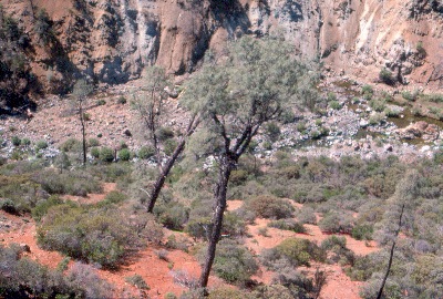
| Metabasalt and metagabbro (greenstone) blocks in the ophiolite often stand in bold relief above the less resistant tectonized ultramafic matrix of a serpentine melange belt. At right is a greenstone "knocker" rising above serpentine chaparral covered slopes near Hunting Creek. D. Enderlin photo. | 
|
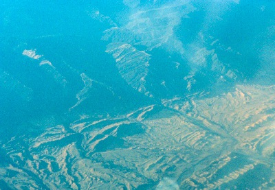
| To the east of the fault is the Great Valley Sequence, an upturned assemblage of Cretaceous-Jurassic forearc basin marine sediments. Most of the formations are lenticular and have poorly expressed mappable boundaries. Hence, they are not true formations. Nevertheless, geologists have tried to assign formation names to units within the sequence in efforts to assist with stratigraphic interpretation! An aerial view of the upturned beds appears at left. N. Lehrman photo. |
| The oldest formation of the Great Valley Sequence is the Upper Jurassic Knoxville (Stony Creek) formation, which makes up the "hanging wall" of the Stony Creek fault at the McLaughlin mine. The image at right shows the typical Knoxville formation landscape of grassland and oak woodland (foreground) abruptly bounded by the Stony Creek fault (yellow dashed line). The chaparral-covered slopes in the distance are underlain by Coast Range Ophiolite. The Knoxville formation hosts a variety of fossil fauna, including the pelecypod, Buchia piochii (Gabb), an index fossil representing the Tithonian Age of the Upper Jurassic. D. Enderlin photo. | 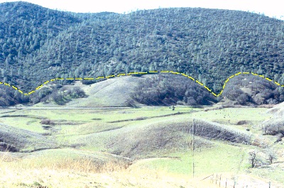
|
| At right, is a side view of the Upper Jurassic pelecypod, Buchia piochii (Gabb), in a lime-rich clay bed (marl) in the Knoxville formation southeast of the McLaughlin mine. For you Jurassic Park fans, this clam was a contemporary of more familiar terrestrial fossils of North America: Allosaurus, Stegosaurus, and the enormous sauropods Apatosaurus (originally called Brontosaurus) and Diplodacus. B. piochii was also a contemporary of the famous transitional bird-theropod, Archaeopteryx, of Bavaria. D. Enderlin photo. | 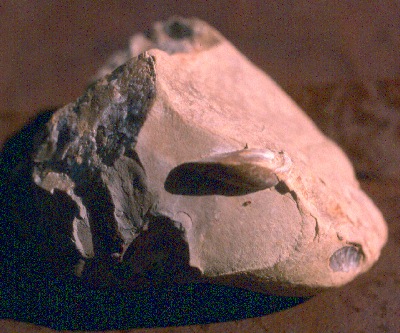
|
| At right, are examples of the fossil belemnite Cylindroteuthis tehamaensis (Stanton), from the Knoxville formation near the McLaughlin mine. In older literature, the belemnite is called Belemnites tehamaensis. D. Enderlin photo. | 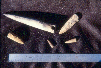
|
| Examples of the brachiopod Peregrinella whitneyii, found in podiform limestone beds in the upper Knoxville formation north of the McLaughlin mine. These limestones are a peculiarity in these deep ocean sediments. Recent research has revealed that these fauna are related to modern counterparts in the Marianas Trench. Submarine serpentine mud volcanoes are found in deep trenches, and are represented in the Great Valley Sequence by lenses of detrital serpentine, such as that found at Little Blue Ridge. Cold mineral water seeps associated with the volcanoes are thought to produce chemo-symbiotic microchemical environments in the deep ocean allowing such species to survive (K. Campbell personal communication). Normally, such animals would die in deep ocean environments below about 4.5 km (the Carbonate Compensation Depth), because their calcareous shells would dissolve! D. Enderlin photo. | 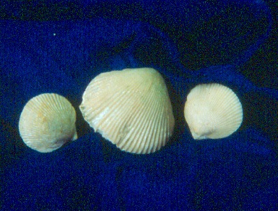
|
| A large fragment of the ammonite Phylloceras knoxvillense (Stanton), found near the McLaughlin mine. To read more about the discovery of this fossil, click here. D. Enderlin photo. | 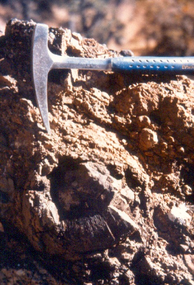
|
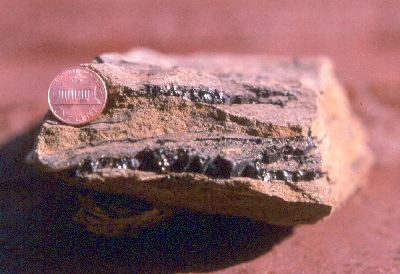
| The Knoxville formation is dominated by deep ocean mudstones and siltstones in its lower strata. Near the top of the formation, rhythmically bedded sandstones and siltstones with minor chert/volcanic pebble conglomerates are common. At left is a sandstone (graywacke) from high in the section. Note the seams of bitumen (a coal-like material) in the strata. This sample was collected along the south shoreline of Davis Creek Reservoir. D. Enderlin photo. |
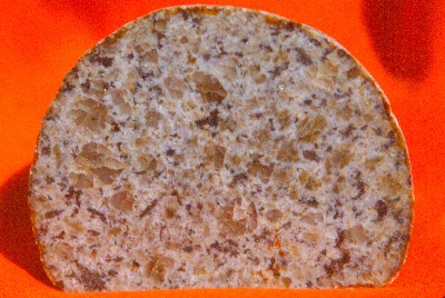
| Stratigraphically above the Knoxville formation is the Cretaceous Crack Canyon formation. Unlike the Knoxville formation, the Crack Canyon formation contains an abundance of coarser clastics, including boulder conglomerate. At left is a polished granitic cobble from this formation, collected at the west abutment of Davis Creek Dam (Hobbit Mountain). The provenance for clasts such as this is thought to be the ancestral Klamath Mountains. D. Enderlin photo. |
| The Mesozoic deposits were emplaced during a prolonged period of plate subduction, wherein an oceanic crustal plate was colliding with, and diving beneath, the North American Plate. The illustration at right shows how this process occurred. The volcanic arc on the right side of the illustration is the ancestral Sierra Nevada. N. Lehrman graphic. | 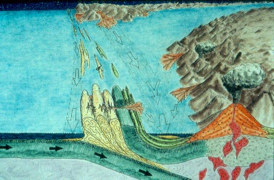
|
| Next Page Previous Page | McLaughlin Deposit Page 1 2 3 4 5 |